Living Streets: Dún Laoghaire is a new scheme for Dún Laoghaire town involving sustainable mobility and public realm improvements. It aims to make our local streets safer and greener, our communities more connected, and to keep our economy vibrant. Works will provide for street and road safety improvements (including pedestrianisation of parts of George’s Street Lower, Sussex Street and Convent Road ), modal filters and park and landscaping improvements in the following areas:
- George’s Street Lower
- George’s Street Upper
- Cumberland Street
- York Road
- Library Road
- Marine Road
- Sussex Street
- Convent Road
- Tivoli Road
- Cross Avenue
- Summerhill Road
- Park Road
- Glenageary Road Lower
- Clarinda Park
The project involves three main elements:
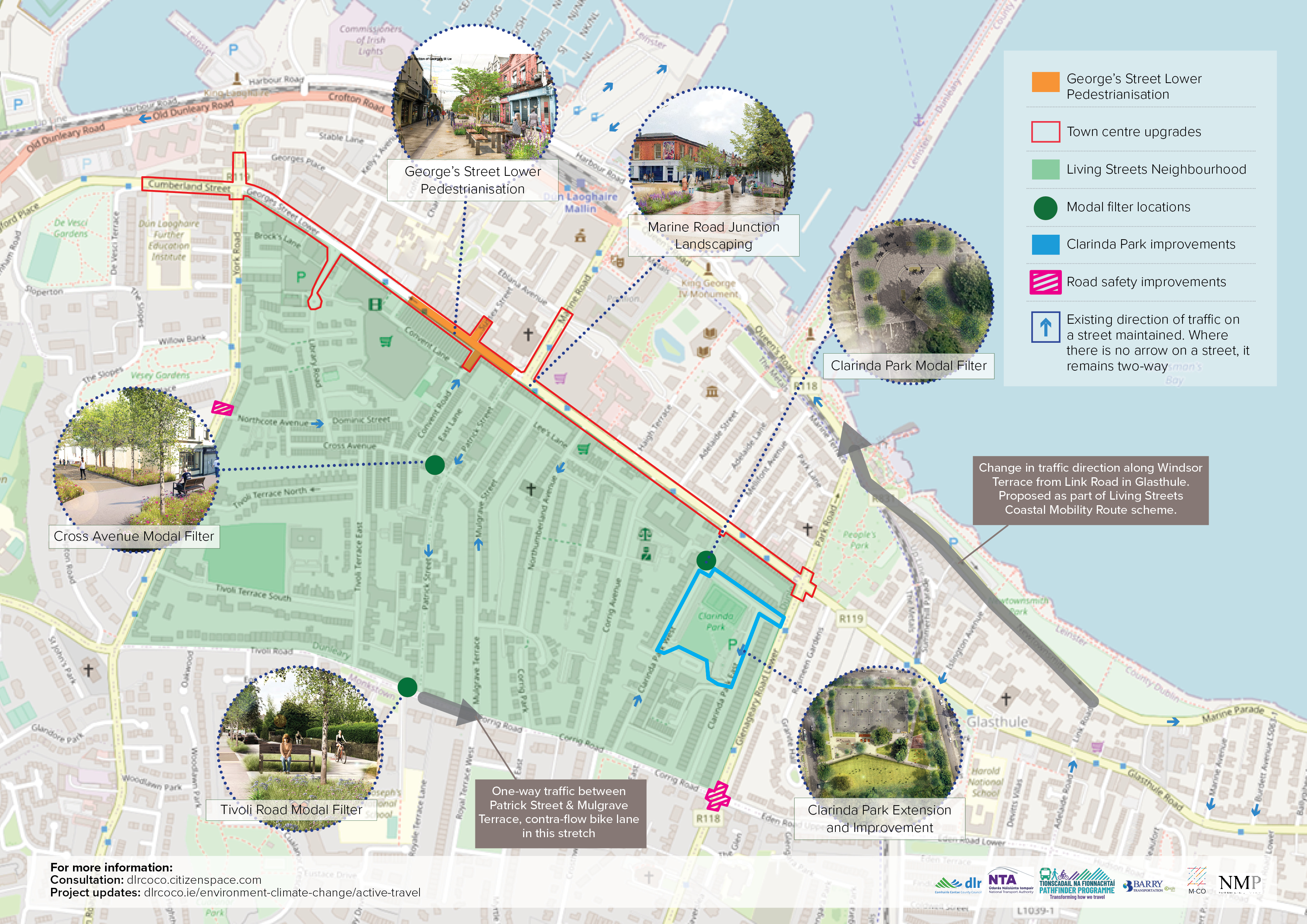
1. Town centre upgrades and the pedestrianisation of part of Georges Street Lower:
It will provide better landscaping, planting, and seating throughout the length of George’s Street to create a safe, welcoming, and vibrant environment. The scheme will pedestrianise 220m of George’s Street Lower from the junction with Patrick Street to St Michael’s Hospital, and part of Sussex Street and Convent Road. The street will remain open for loading and deliveries in the morning. Two clear areas will be maintained on either side of the street and, the central area of the street will feature new seating, planting, and areas for loading.
2. Living Streets Neighbourhood – incorporating modal filters and placemaking:
Through traffic is a crucial contributor to traffic problems in Dún Laoghaire. Currently, 59% of Monkstown-bound traffic in Dún Laoghaire is through-traffic. Modal filters are proposed on Tivoli Road, Cross Avenue and Clarinda Park West to deter through traffic while still allowing destination traffic to the town centre and houses within the area. A key benefit will be quieter, safer roads with less traffic and pollution. It also frees up road space for improved public realm e.g. planting, seating, and outdoor dining.
There are also plans to improve Clarinda Park by restoring the park to its original historic boundary with more green space and landscaping.
3. Sustainable mobility improvements:
A safer walking environment will be created through reduced traffic overall. Within the Living Streets Neighbourhood and on key roads in the town, damaged pavements will be fixed, and footpaths will be widened where space allows. Pedestrian crossings will be improved throughout the area, and cycling will be more convenient, enjoyable, and safer for all.
The junction of Glenageary Road Lower and Corrig Road will be upgraded, removing street clutter where the footpaths are narrow, reducing the length of pedestrian crossings and providing more footpath space for pedestrians waiting to cross the road. A new signalised pedestrian crossing is also proposed on York Road at Northcote Avenue to allow pedestrians to safely cross the road here, as well as serve as a traffic calming measure.
Living Streets: Dún Laoghaire – scheme overview map:
EVENTS
• Webinar: 23 November, 7-8 pm – Register here: https://us02web.zoom.us/webinar/register/WN_2LeWm9yvSTib99WOgWuu5A
• Drop-in Information session: 28 November, 5-8 pm, Dominican Primary School
• Pop-Ups
Why your views matter
Submissions must be made within the display period, which runs from 2nd November to 14th December 2023. Late submissions will not be accepted.
You are encouraged to use the online submission facility, but submissions will also be accepted by email [email protected] or post to the following address:
- Senior Engineer, Active Travel, Infrastructure and Climate Change Department, Dún Laoghaire-Rathdown County Council, County Hall, Marine Road, Civic Hub, Dún Laoghaire, Co. Dublin, A96K6C9.
- Hard copies of the survey will be available in Lexicon, Blackrock, Deansgrange and Dalkey libraries.
To access the survey, please click here